Highway Design and GIS Course
Advance Transportation Design Using Civil 3D, InfraWork & QGIS for Professional
Become a Highway Design Expert or Professional, No experience required
Admissions Open Start Your BIM Journey Today
Application closes on 25 Oct 2025 !
Program Outcomes
Elevate your Career with Advanced Transportation Design Using Civil 3D & InfraWorks program
Become a Design Engineer, GIS specialist and BIM Modeler
- Learn about workflows, regulations (ISO 19650, AASHTO, IRC), and basic understanding of transportation infrastructure modeling tools like Civil 3D, InfraWorks & QGIS
- Experience the 3D road tool for your alignments, intersections, grading, drainage & roadway modeling
- Use Navisworks & speckle for 4D & 5D cost estimating and project scheduling/implementation
- Work in the field of 3D transportation modeling using QGIS & InfraWorks for terrain, GIS mapping & environmental analysis
- Experience real-world civil programs including highways, metro rail, urban planning & smart city
- Develop deliverables with professional quality: drawings, reports, and 3D visualizations of transportation design
- Connect the Cyclone in Civil 3D with ACC Docs and ACC Build & ACC Design Collaboration for workflows in the industry
Learn More About the Course
Eligibility Criteria
Lorem ipsum dolor sit amet, consectetur adipiscing elit. Ut elit tellus, luctus nec ullamcorper mattis, pulvinar dapibus leo.
Who Should Enroll?
This course is intended for: - Students & Civil Engineers engaged in a transportation project - Transportation Engineers & Highway Designers - BIM and Infrastructure Consultants - Architects & Urban Planners - Traffic Engineers, Surveyors & GIS Professionals - Civil Infrastructure construction Managers on 3D projects
Technical Skills
Fundamental experience with AutoCAD or close equivalent design tools Understanding of roadways, metro rail, bridges, sewer systems, pipe design and smart city initiatives Prior exposure to transportation engineering design software is desirable but not essential.
Program – highlights
Why Choose Transportation Design Using Civil 3D & InfraWorks, QGIS Program
High Demand in Infrastructure Industry
There are more than 1000+ companies currently hiring individuals with soft skills in transportation engineering design software and 3D infrastructure design for roads, highways, airports, rail, renewable energy, and smart city projects. Experience with 3D modeling in transportation and GIS integrations prepares you for future digital construction.
Industry-Oriented Hands-On Training and 100% Career Support
With our program, we integrate live case studies, software training, and projects that help you build a portfolio. You will work with software modeling transportation infrastructures, become experienced with 3D road software, complete the program with career services support — from interview preparation to job referrals.
Flexible Learning with Expert Guidance
Through live one-on-one sessions and live projects, you will receive practical experience in road software 3D, transportation 3D design, and civil infrastructure 3D. Learn at your own pace with 5+ industry leading tools, including InfraWorks, Civil 3D, and QGIS.
Future-Ready with Digital Construction Trends
Explore Discover how 3D infrastructure design is transforming highways, metros and smart cities. See how transportation engineering design software facilitates working with both the public and private sector to maintain cost controls, improve efficiency as well as smarter planning.
Secure Top Design Engineer Jobs in Transportation
Salary Range
Individuals in their early stage of career in the transportation engineering design software and transportation infrastructure modeling software industry (including GIS and BIM), can expect salaries between ₹3 LPA and ₹8 LPA depending on skill sets and expertise in the software.
Job Growth Rate Annually
The need for civil engineers with expertise in 3D infrastructure design and transportation 3D design is expected to rise at a rate of 9% from 2022 through to 2038, largely due to large, global infrastructure projects.
Top Hiring Countries
India, UK, UAE, Germany and Australia are the largest recruiters of road software 3D, civil infrastructure 3D, tunnels, metro, highways, rail projects, smart cities, and GIS-based planning.
Career Roles in BIM for Transportation
Here are the roles and responsibilities typically associated with Civil 3D, GIS, and InfraWorks in civil infrastructure and planning projects
- Design Engineer - 3D design of transportation / road-oriented planning.
- Civil CAD/BIM Modeler - 3D civil infrastructure and visualization specialists.
- GIS Specialist - Integrating GIS data with transportation infrastructure modeling software.
- Civil 3D Technician - 3D road software, focusing on design and simulation.
- PHE Design Engineer - Designing public health engineering in a 3D infrastructure discipline.
Get Professionally Certified in Transportation with BIM
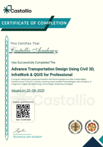
Earn a professional ISO certificate that officially recognizes your expertise in Transportation Design using Civil 3D, InfraWorks, and QGIS. Develop practical skills in road, highway, and rail design through Civil 3D and BIM workflows. Enhance your resume and boost your credibility. This certification is ideal for civil engineers, designers, and BIM professionals who are ready to take a leading role in modern infrastructure projects.enhance your credibility Ideal for civil engineers, designers, and BIM professionals ready to lead in modern infrastructure projects..

Frequently Asked Questions
Civil 3D is used for detailed engineering design and drafting in transportation projects. It excels in road and highway design, including alignment, grading, drainage, and stormwater management. Civil 3D helps engineers develop detailed, accurate, and efficient designs while performing crucial analysis like earthwork calculations and corridor modeling.
While QGIS is not designed specifically for detailed road design like Civil 3D, it is invaluable for geospatial analysis, land-use mapping, and environmental assessments. QGIS can be used to analyze topography, land use, and environmental features, providing crucial data for transportation planning. It is often used for pre-design analysis and integrating geospatial data into other design software.
Yes, Civil 3D models (e.g., road corridors, grading, drainage) can be exported to Navisworks for coordination, clash detection, and visualization. Navisworks allows you to combine Civil 3D models with other disciplines, such as structural or MEP systems, for comprehensive project coordination.
Yes, Civil 3D is user-friendly for beginners, especially those new to computer-aided design (CAD) in civil engineering. However, the learning curve can be steep for absolute beginners, so a step-by-step, structured course will help you master the software effectively.

